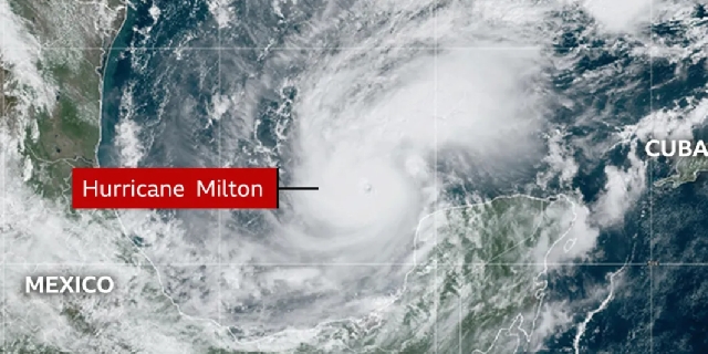
Florida warned of 'potentially catastrophic' Hurricane Milton
 Hurricane Milton
US officials have warned of the threat to life posed by Hurricane Milton, which briefly became a category five storm before returning to category four as it heads towards Florida.
Milton is still packing ferocious winds of up to 155mph (250km/h) as it moves past the northern edge of Mexico's Yucatan peninsula. Forecasters from the National Hurricane Center (NHC) say "potentially catastrophic" storm surges are possible along coastal areas.
The storm is expected to hit the heavily populated city of Tampa Bay with full force on Wednesday, less than two weeks after the state was hit by Hurricane Helene.
Floridians have been told to prepare for the state's largest evacuation effort in years.
Governor Ron DeSantis has warned that time for people to evacuate is quickly running out.
"We have to assume this is going to be a monster," DeSantis said at press conference on Monday afternoon, as officials warned of the storm's category five status.
Warnings over Hurricane Milton come just 10 days after Hurricane Helene - the deadliest mainland storm since Katrina in 2005 - pummelled the US south-east, killing at least 225 people. Hundreds more are missing.
At least 14 of those deaths were in Florida, where 51 of 67 counties are now under emergency warnings as Milton approaches.
"Unfortunately, some of the Helene victims are in the path of this storm," DeSantis said.
Ken Graham, director of the National Weather Service (NWS), said Milton had become a category five hurricane at record-breaking speed - with wind speeds intensifying by 80 knots (148km/h) over 24 hours.
"That's the third highest we have on record," he said.
Hurricanes are separated into five categories based on their wind speed.
Those reaching category three and higher are considered major hurricanes because of their potential for significant loss of life and damage, according to the NWS.
Hurricane Milton is expected to weaken on Tuesday as it travels over the Gulf of Mexico, dropping to a category three storm by the time it makes landfall in Florida's Tampa Bay on Wednesday evening or early on Thursday.
The National Hurricane Center warned torrential rain and flash-flooding can be expected across parts of Florida from late Monday.
It added that life-threatening storm surges and damaging winds along portions of Florida's west coast were possible from late Tuesday or early Wednesday.
Rainfall totals could reach localised highs of 15in (38cm), and coastal areas could see storm surges of 10-15ft (3-4.5m).
Counties began issuing evacuation orders on Monday, and tolls will be suspended on roads in western and central Florida.
Long queues at petrol stations began forming in south Florida, with some reports of stations running out of fuel.
Traffic congestion in some areas has increased by as much as 90% above average, DeSantis said.
School closures in several counties begin on Tuesday.
Keith Turi, a spokesperson for the Federal Emergency Management Agency (Fema), said: "I’m encouraged by the amount of evacuation that’s going on right now."
"This is actually a good sign."
Parts of Pinellas County, where at least a dozen people were killed by Helene, were placed under evacuation orders on Monday.
Airports in Tampa and Orlando announced they would be suspending flight operations from Tuesday because of the storm.
Source: BBC
Trending World

BBC complains to Apple over misleading shooting headline
04:58
West Africa bloc meets as military rulers vow to quit
16:09
2024 African elections: Some ruling parties retain power, some suffer defeats
14:54
Human Rights Watch accuses Sudan’s RSF of rape, sexual slavery
04:06
Nigeria investigates nearly 800 suspects arrested in massive cybercrime raid
03:08
Storm Chido kills at least 7, leaves trail of damage in Malawi
03:05
More than 2 million Nigerians kidnapped in one year, survey finds
05:32
China counting on cyber-psychological cocktail to expand dominance
11:33
Mogadishu development project brings hope to Somalia
11:41
Myanmar ethnic rebels say they’ve captured junta western command
11:37


